Leys (or 'Ley Lines') and Alfred Watkins as a Pioneer: Ley Hunters and Ley Deniers by Rae WestClick for Index to all my general interest items collected in one file Click for Home page of entire big-lies.org site  Notes on what might be a serious discovery, a reshaping of perceptions of the remote past.
This is a combination of three book reviews (from elsewhere on this site; also on Amazon): two of books by Alfred Watkins, The Old Straight Track (1925) and The Ley Hunter's Manual (1927). And a biography of Watkins by Ron Shoesmith. I've added very detailed notes following the reviews which I hope are clear and accurate. The Old Straight Track was a pioneering book, presenting a rational theory of prehistoric landscape awareness and mobility. But the book has been, and still is, misrepresented by both supporters and opponents. The Old Straight Track - Review Fascinating if over-detailed book (Watkins' 'The Ley Hunter's Manual' is I think better). Poor Watkins is misrepresented by both friends and enemies—the latter mostly professional archaeologists. Trying to summarise: Watkins realised (he was among other things a commercial traveller around Herefordshire, and was well aware of the problems of finding one's way round, and the importance of landmarks) that prehistoric man had a problem of transport. To take one example: salt. There are local deposits of this in Britain; but projecting time backwards, how could the stuff be moved around? There were no motorways, or even roads; no tarmac; no motor traffic; no bikes; no maps; not even weedkiller to keep paths clear... obvious points which many people seem unable to grasp. Watkins' theory was simply that straight tracks were laid out by line-of-sight and marked by whatever method was feasible—dug-out notches on the skyline (early man could do earthmoving on quite a scale), upright stones arranged in pairs to point the way, perhaps church steeples (assuming site continuity), large stones by the pathside—of types not found locally, to remove doubt. Watkins thought some large flat stones marked with cup and ball marks might be in effect maps of local 'hill forts'. He thought Silbury Hill was built specifically as a landmark. He stated that covered tombs were built not on tops of hills, but arranged in sight of valley bottoms. Trees were another possibility, though obviously they would be visible now, if at all, only by traces. Another of Watkins's examples was water: springs of clean water were presumably a useful asset (and some contained health assisting minerals, though obviously we're in eras predating chemical knowledge). Paths to them might be marked out. And much more in this vein, including signalling by means of beacon fires. His SUPPORTERS have often taken a description by Watkins of a sudden insight into this possibility ('wires.. across the countryside') in an electrical sense, adding a whole assemblage of material on sacred sites, lights, currents, electric charges and shocks, and what have you. And of course there was a temptation to rule lines on the then-new Ordnance Survey maps. They also renamed as 'ley lines' what Watkins christened 'leys'. His OPPONENTS generally laid into the detail—place-names for example obviously are a high-risk source of evidence. So are buildings—many 19th century churches are built in mock-old styles to look ancient and traditional, many manor houses aren't reliable indicators of archaeological precedents, etc. I think there was also a class element here: archaeologists like, or liked, to look at palaces, villas, military structures, cathedrals, massive megaliths, impressive graves, treasure hoards, and generally high status things. Watkins tried to redirect attention to humble practical tracks and paths. The Ley Hunter's Manual - Review Brilliant book, amplifying Watkins' 1921 discovery. Full of speculative details. Watkins' view of the remote past is: Man in hunting phase: salt, flint only to be obtained from afar. He'd ascend a hill, seek farthest peak 'in the direction he wanted to go.' Two staves were the first surveyors instruments: cairns, stones etc. were markers. [Later note: the then-rather-new detailed Ordnance Survey maps of Britain allowed hypotheses to be checked, up to a point, without an enormous amount of field work trying to rediscover lost tracks. I suspect Watkins may have travelled on horseback, which may have made travelling away from roads easier for him. Pp 81 and 83 mention two leys, specifically described as short or 'Little'; the latter is eleven miles long. Conversely, the effort and difficulty involved must have put off many archaeologists from investigating. Note that a lot of Watkins's suggestions are still omitted by people who wish to stress mystery, the unsolved problems, etc. There isn't always hostility between official archaeologists and ley line enthusiasts: Chippindale of Cambridge and Devereaux for example were on good terms.] Review of Ron Shoesmith's biography Alfred Watkins: A Herefordshire Man provides a verbal portrait along these lines:- Watkins is under-rated, mainly because he devised a new idea which academics hated, though they weren't very successful in opposing him. At least one book was written purely as an attempt at refutation. Watkins invented the idea of 'leys', *not* 'ley lines'. The idea was that lines of sight were important; in times before maps, roads, and big towns, not to mention sat navs and signposts. He invented the engaging idea that inland trading routes had to go long distances, and of course it was important not to get lost en route—not an easy trick when paper and ink, tarmac, road rollers, stone moving equipment, and weedkillers barely existed. Stone markers in lines, the 'gwlch'—a scooped-away path visible on the horizon—beacons, burial and other mounds—including Silbury Hill—and generally things exploiting the straight line aspect of light were in his view arranged and designed as early straight-line tracks. I suspect much of this was thought up by Watkins as he travelled around Wales selling and promoting some of his business ideas. (He was—inter alia—an early photographer, processing his own glass plates with their silver halide emulsions, and who patented his own exposure meter. His books are illustrated with his own black and white photographs of stone monuments, church spires as possible alignment markers, paths with suggestive directional features, stones with cup and ball marks, and similar details). He appears as a man in a respectable suit, middle-aged, solemn and serious, surveying the world through spectacles. He founded a club and his ideas led to enthusiasts with maps and rulers trying to find networks of lines in a probably unrealistic fashion. I would guess more attention will be devoted to him in time—not many people can invent a new way to picture the world. I think he may have influenced Belloc, who also wrote on trackways, though mainly to do with pilgrims' routes. I suspect Tolkien had some knowledge of his books, too; 'the road goes ever ever on'. I suspect also that Trevelyan of the Youth Hostels Association and other walkers and ramblers might have liked the idea of healthy outdoor exercise with unprofessional research into the past. Watkins extended his ideas abroad, even including stupas in India as perhaps markers, and ideas from National Socialist Germany, and even the lines at Nazco. This biography however, though affectionate, is a bit short. It isn't very detailed, but so far as I know is the only one available as a mass-market book. Shoesmith was (perhaps is?) Hereford City Archaeologist; his book was first published in 1990.
Very Much More Detailed Notes on Alfred Watkins and Leys. Academic Fight Back: Williamson & Bellamy's book Ley Lines in Question (1983) Ten chapters, posing as a serious investigation. Glyn Daniel, a sort of official Pelican book and BBC-style archaeologist, read their MS. It's amusing to note their maliciously derogatory tone throughout this book: '... traipsing around ... to photograph stones. ... often told he was 'derided' and 'ridiculed'.. more true to say that the discovery [sic] was ignored by the archaeological hierarchy.. Contemporary academics doubted that prehistoric savages had either the desire or the ability to establish a unified and elaborate network across the entire country... On 7th April 1935 the grand master of ley studies finally gave up the ghost...' Williamson & Bellamy conflate Watkins' ideas with (for example) those of Devereux & Thompson, Janet and Colin Bord, and John Michell. What's also irritating is that they have no idea that Watkins' folk or fairy tales, e.g. of giants dropping stones, are partly explanatory tales, not, presumably, to be taken literally. Any more than Normans emerging from their castles were regarded as genuine giants. Possibly this is a similar error to assuming "Thomas Wolsey built Hampton Court" meant Wolsey was a superman. At any rate, the reader has to tolerate e.g. 'not all believers in leys think ancient Britons could levitate' and comments on stones revolving or dancing. There's detail on 'zodiacs' as far as I know all post-dating Watkins' death. The comment on a 'unified network' is the same style of misrepresentation. I'm not so sure about 'dowsing' which Watkins would no doubt have heard of, and may, or may not, have believed in, but which in any case is of no relevance to trackways. I'll just bullet-point some failings of this book:- • The authors don't appreciate the point about a spire as being a thing visible from some distance; potentially therefore the site of a long-term landmark. Instead there are folk tales about churches moving overnight and so on • 'Foundation stone' is not in the index, or anywhere in the text, despite Watkins on the symbolism • The words notch, gap, scar, and even skyline are not in the index; yet, if leys existed, man-made cuttings would be one of the few surviving pieces of direct evidence as opposed to indirect inference • The authors don't appreciate that evidence of a long trackway, if one existed, no doubt overlain by relatively new buildings and other features, may almost entirely have vanished; geological and historical change would need to be considered. It isn't just a trivial matter of going out for a look; as here: 'A ley-line can easily be found and confirmed in a week-end' • Watkins tried to generalise overseas: he mentioned claims of similar tracks in Indian North America, India, Biblical countries, Uganda and elsewhere. None of these is indexed • Watkins' claim that Silbury Hill was deliberately arranged so its top is visible from surrounding areas is not brought up at all by Williamson and Bellamy; they make an irrelevant point about the Jewish fraud of 'orgone energy', 'discovered by the scientist Wilhelm Reich'. They also make an alarming mistake about the structure of Silbury Hill, claiming it had an internal chamber • 'Hillforts': Watkins claims that, originally, their sites (or some of them) were arranged to be serially visible to travellers below, so that as one disappears another suddenly becomes visible. He considered hill forts to be a late development. Williamson and Bellamy made no attempt to verify or check this claim. It may be worth quoting them at some length to see the irrelevance of their attitude to Watkins, and their naive cocksureness: (p 68) 'There is nothing particularly mysterious about hill forts; excavation unequivocally shows that they were built for purposes of defence, and the current claim that they were unoccupied is false. Watkins used twelve Herefordshire hill forts in his leys, and of these four have been extensively excavated, and two have been subjected to small-scale probing. It seems reasonable to accept the results of these .. as representative of others in the area. One, Croft Amburey, is a hill fort on the first ley that Alfred Watkins ever discovered. .. the interior contained rows of rectangular huts, implying a dense population of as many as 70 people per acre. Two, Credden Hill Camp, the ramparts of which Watkins found to be determined by three leys, was excavated in 1963. It was permanently occupied from about 390 BC until AD 75 approximately, with a population at any one time of about 4000. Three, Midsummer Hill and Sutton Walls were clearly permanently occupied villages. The former may have had a population of up to 2000. For Dinedor and Akenbury, though not extensively excavated, both revealed evidence of permanent occupation such as storage pits, domestic refuse and internal buildings. .. These results from 'Antiquity' and some of them are privately published.. The vast majority of excavated hill forts have shown Iron Age occupation to have been the first on the site, and of the excavated Herefordshire hill forts mentioned above none produced evidence of earlier activity. The same is true of all the hill forts in our sample of leys. ...' • On the word 'ley'; Williamson and Bellamy seem unaware that Watkins christened them with that name, and was perfectly aware that it may not be what people called them at the time. But whatever the name was, the things may have existed anyway, and in Watkins' view they did • Statistical arguments related to points and straight lines. This sort of material seems to have considerable longevity; one of Britain's junk newspapers, the Guardian, has occasional articles on the numbers of buildings in Britain and the numbers on straight lines. This of course completely misunderstands the whole point about laying out paths which can be reliably followed • Light as a device to attract attention: this was an important part of Watkins' work, and the idea of man-made moats to reflect light, as an obviously artificial feature, is credible, given the earthworking abilities of ancient peoples. The town of Beaconsfield and others, and the possible use of light and reflecting circles of water, 'beorhs' and 'haloes' and so on, is simply ignored completely; it's just not mentioned anywhere, except as 'beacons are not as popular as they used to be.' • Watkins' surveying idea, with the 'dodman' as his word for such persons, is mentioned just three times in this book. There is no consideration, pro or con, of how such a surveying technique would operate in practice. • Plenty more. However it's clear the authors wanted to side with what they call 'educated professionals' and had no serious interest in investigating Watkins' hypothesis. Alfred Watkins: Proof of Ancient Track Alinement [sic] (1931) It has to be said that Alfred Watkins was not his own best advocate. This 1931 piece consists largely of extracts from 'The Ley-Hunter's Manual' of a few years earlier, but is mostly mathematical: he attempts to prove there's a very remote possibility of points being in a line but he seems to have got a bit overwhelmed with maps - '51 churches, practically all ancient, on an Andover map' and with a ruler rather than actually going out to see. He draws little crosses on a paper to estimate probabilities with random dots. A very empirical thing, not impressive. A better approach would be to use contour maps with some sort of tangents constructed from possible sighting points, something possible with computers but not very practical at the time. Here's Watkins' own statement on Proof: 'The proof is chiefly to be found in the fact of certain classes of what are now called ancient monuments aligning with each other, and in fragments of present-day roads or paths being occasionally found on such track-lines. In some cases, however, the alignments have no indications of having been made for track purposes. ... The deduction of an organised system of straight tracks in prehistoric Britain is denied by many critics who put it down to imagination and accidental coincidence and infer [sic] that the theory was formulated first and the facts then selected to fit it. The inference is not correct in my case, for it was not until a large number of alignment facts had been observed that any theory or outline for further investigation was formed as a deduction. ..' Email me Click for Index to all my general interest items collected in one file Click for Home page of entire big-lies.org site ©RW 2013-10-04 Book review of Watkins first uploaded 2010-10-07; Shoesmith review 2009-02-19. Williamson & Bellamy review uploaded here 2013-10-06. Other material mostly written before 1997. |
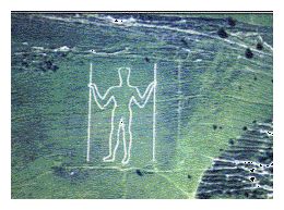 Watkins considers track directions would be surveyed using upright rods, to prolong straight lines out of sight of their landmarks. As supporting evidence he notes the Wilmington Long Man (see photo), and a similar man with staves at Lake Onega, Russia. (This latter may not have survived the mass murders by Jews; I have yet to see an image of it).